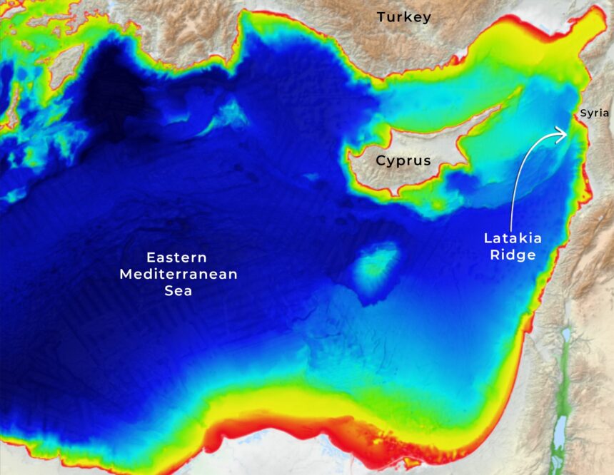
ai mapping — AI mapping has revealed intriguing geometric structures half a kilometre beneath the sea on the Latakia Ridge, situated between Cyprus and Syria. Explorer Robert Sarmast is set to present these AI-enhanced underwater maps at an event hosted by the University of Cyprus on 26 November.

Photo: in-cyprus.philenews.com
This presentation marks Sarmast’s return to Cyprus nearly two decades after his deep-sea expeditions in 2004 and 2006, which brought significant attention to the Latakia Ridge as a potential site of ancient habitation.

Photo: in-cyprus.philenews.com
Ai mapping: Unveiling the Anomalies
The Latakia Ridge Research Institute (LRRI), established by Sarmast in 2025, utilised an AI anomaly-detection model to analyse regional bathymetric data from the Eastern Mediterranean. The system was tasked with identifying elements that deviate from the typical geological background.
The AI pinpointed a location on the summit of the Latakia Ridge that features a flat rectangular basin with well-defined edges. Surrounding this basin are perimeter embankments that create a trench-like enclosure, alongside a canal-like cut at right angles to the internal slope and an elevated channel that traverses the basin. Additionally, two triangular mounds are symmetrically positioned across a straight canal.
Scientific Community Invited to Engage
According to the LRRI, multiple independent datasets have verified that these patterns are not mere mapping errors. Sarmast clarified, “We are not announcing the discovery of a lost city. We are announcing a very specific, highly geometric anomaly that we can’t yet explain—and we are inviting the scientific community to help us test it.” This statement underscores the importance of collaboration in understanding the structures found.
Context of the Discovery
The newly identified site lies several kilometres away from the areas explored during Sarmast’s previous expeditions. Those earlier missions did not have access to technology capable of fully resolving the region’s complexities. The LRRI suggests that if the structures are proven to be engineered, they may support theories proposed by Russian geophysicists in the mid-20th century, which posited that parts of the north-eastern Mediterranean might have been above sea level more recently than conventional Western timelines suggest.
Future Exploration Plans
Sarmast’s upcoming visit also aims to initiate planning for a new scientific expedition departing from Cyprus. This proposed mission seeks to gather physical evidence through core sampling of sediments at the summit of the Latakia Ridge, alongside high-resolution multibeam sonar surveys, sub-bottom profiling, and visual imaging of the identified structures using ROV/AUV technology.
Public Engagement and Educational Outreach
The free public event at the University of Cyprus will take place from 6pm to 8pm on 26 November, with doors opening at 5.30pm. Attendees will have the opportunity to hear the presentation in English, with summaries available in Greek, Russian, and Arabic. Additionally, Sarmast will conduct private briefings with scientific and regional representatives from Cyprus, Syria, and Russia, further fostering collaboration in this area of research.