The recent wildfires in Cyprus have devastated approximately 125 sq.km in the Limassol district, cyprus wildfires as confirmed by satellite survey data from a local research centre.
- The recent wildfires in Cyprus have devastated approximately 125 sq.km in the Limassol district, cyprus wildfires as confirmed by satellite survey data from a local research centre.
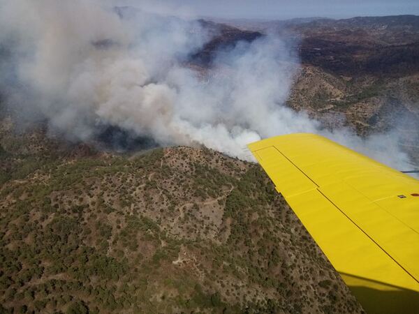
Breaking out on Wednesday and extinguished late on Thursday, the fire has taken two lives and prompted the evacuation of 14 communities, particularly threatening the region’s famed wine country. The situation was worsened by strong winds and soaring temperatures reaching near-record highs of 45 degrees Celsius.
Initial assessments by the fire service pointed towards arson as a possible cause, but this claim was quickly denied by government officials who faced backlash over perceived incompetence in handling the crisis.
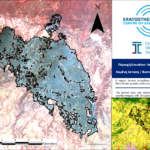
Cyprus wildfires: Assessment from the Eratosthenes Centre of Excellence
The damage estimation was conducted by the Eratosthenes Centre of Excellence, a research hub established by the Cyprus University of Technology in 2007. Using high-resolution PlanetScope satellite images taken early Thursday, the Centre aims to provide an accurate assessment of the fire’s impact.
In a statement, the Centre indicated that “as the fire was still active at the time of image acquisition, a revised assessment will follow using the next available satellite image to minimise potential errors caused by smoke and to enable a comprehensive damage evaluation.”
Impact on Vegetation and Land Use
According to data from the European Space Agency’s WorldCover Programme, the burned area comprises a mix of ecosystems: 50% grassland, 31% sclerophyllous vegetation, 16% tree cover, and 1.3% built-up areas. This diverse impact highlights the ecological toll of the fire on the region.
Role of the Eratosthenes Centre
Since becoming autonomous in 2019, the Eratosthenes Centre has received €38 million in funding from the EU and Cyprus. It serves as a digital innovation hub, employing space technologies, remote sensing, and earth observation data to address environmental and climate challenges, including wildfires and floods.
As the community grapples with the aftermath of this disaster, the Centre’s ongoing research and data analysis will be critical in understanding the full extent of the damage and informing future fire management strategies.